
UAV remote sensing technology Unmanned aerial vehicle
1. Introduction to drone remote sensing
Unmanned Aerial Vehicle Remote Sensing (Unmanned Aerial Vehicle Remote Sensing) not only uses advanced unmanned aerial vehicle technology, remote sensing sensor technology, telemetry and remote control technology, communication technology, GPS differential positioning technology and remote sensing application technology, it has automation, intelligence, and specialization to quickly acquire the land, Resources, environment and other space remote sensing information, complete the application technology of remote sensing data processing, modeling and application analysis. Due to the advantages of maneuverability, speed and economy, the UAV remote sensing system has become a hot topic for various countries in the world. It has gradually developed from research and development to practical application, and has become one of the main aviation remote sensing technologies in the future.
2. Application features
UAV is an unmanned aircraft that is controlled by radio remote control equipment or an onboard computer program control system. UAVs are simple in structure and low in cost. They can not only complete tasks performed by manned aircraft, but are also suitable for tasks that are not suitable for manned aircraft, such as geological disaster surveys in dangerous areas, air rescue command and environmental remote sensing monitoring.
According to the system composition and flight characteristics, UAVs can be divided into two categories: fixed-wing UAVs and unmanned helicopters.
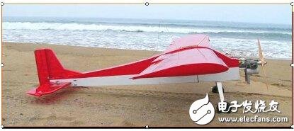
Figure 1 Fixed-wing UAV
Fixed-wing UAVs realize take-off, landing and flight through the sliding of the power system and wings. Both remote control and program-controlled flying are easy to achieve. They are also relatively resistant to wind and have many types. They can simultaneously carry multiple remote sensing sensors. Take-off methods include taxiing, catapult, vehicle-mounted, rocket-assisted and aircraft launching, etc.; landing methods include taxiing, parachute landing, and net collision. The take-off and landing of fixed-wing UAVs requires a relatively open field, which is more suitable for applications in mining resources monitoring, forestry and pasture monitoring, marine environment monitoring, pollution source and diffusion situation monitoring, land use monitoring, water conservancy, power and other fields.
The technical advantage of unmanned helicopters is that they can take off and land at fixed points and do not have high requirements on the conditions of the take-off and landing sites. Their flight is also controlled by radio remote control or program control through onboard computers. However, the structure of unmanned helicopters is relatively complex and difficult to control, so the types are limited. They are mainly used in the investigation of emergencies, such as single landslide survey, monitoring of volcanic environment and other fields.
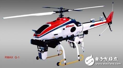
Figure 2 Unmanned helicopter
Remote sensing sensors are based on different types of remote sensing tasks, using corresponding airborne remote sensing equipment, such as high-resolution CCD digital cameras, light optical cameras, multi-spectral imagers, infrared scanners, laser scanners, magnetic measuring instruments, synthetic aperture radars Wait. The remote sensing sensor used should have the characteristics of digitization, small size, light weight, high precision, large storage capacity, and excellent performance.
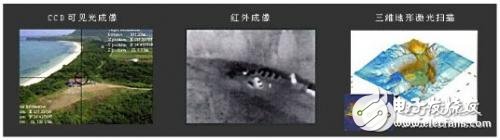
Figure 3 Obtaining a variety of remote sensing imagesÂ
Current UAV remote sensing systems mostly use small digital cameras (or scanners) as airborne remote sensing equipment. Compared with traditional aerial photographs, there are problems such as a larger number of images, and the characteristics of remote sensing images and cameras Calibration parameters, posture data during shooting (or scanning) and related geometric models are used for geometric and radiometric correction of images, and corresponding software is developed for interactive processing. At the same time, there are software for automatic image recognition and fast splicing to realize fast inspection of image quality and flight quality and fast data processing to meet the real-time and fast technical requirements of the entire system. For further modeling and analysis, use the corresponding remote sensing image processing software.
3. Application examples
(1) The Spatial Information Research Center of the Faculty of Science of National Taiwan University used drones to shoot low-altitude large-scale images, and cooperated with FORMOSAT2 classification to extract abnormalities, interpret the illegal waste accumulation (solid waste, etc.) in Taoyuan County for environmental pollution and law enforcement investigations.
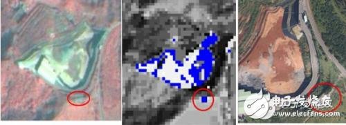
Figure 4 FORMOSAT2 Figure 5 Classification result Figure 6 UAV image
(2) Nicolas Lewyckyj and others in the United States used UAV-RS
The technology conducts natural disaster surveys in North Carolina, and accurately assesses the loss of houses and villages through orthophoto processing and analysis. It shows the rapid response capability of UAV remote sensing technology and provides timely and accurate data for disaster management.
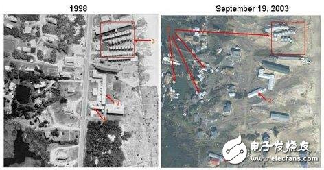
Figure 7 Picture before the disaster Figure 8 Picture after the disaster
4K Home Projector-watch ultra-high-definition movies without going out. Very suitable for home, office and school, compact design, powerful functions, this projector must be your best partner for entertainment or work.Thanks to the wireless connectivity, you'll be able to use it to download the videos, share files, enjoy more media activities.
4K Home Projector,Best 4K Projector,4K Projector,Full Hd Projector
Shenzhen Happybate Trading Co.,LTD , https://www.szhappybateprojectors.com